NASA releases a satellite-based assessment estimating widespread damage across Venezuela following last week’s earthquakes. Multiple outlets report that NASA analyzed imagery from space to identify impacts and provide information for on-the-ground response. NDTV and India Today cite NASA’s use of satellite images and data to support teams assessing conditions on the ground and to help guide response efforts. India Today reports a figure of 58,870 buildings damaged based on NASA’s scan, while NDTV also references an estimate of 58,000 buildings. Breitbart reports a similar, more specific range, saying nearly 60,000 buildings—about 58,870—were likely damaged or destroyed, based on a rapid assessment. Across the reports, the figures align closely and describe damage estimates derived from satellite imagery rather than confirmed structural inspections. The articles agree that NASA’s imagery is used to help quantify damage at large scale and support humanitarian and emergency planning as assessments continue.
NASA satellite imagery estimates about 58,000 buildings damaged in Venezuela earthquakes
NASA releases a satellite-based assessment estimating widespread damage across Venezuela following last week’s earthquakes. Multiple outlets report that NASA analyzed imagery from space to identify im...
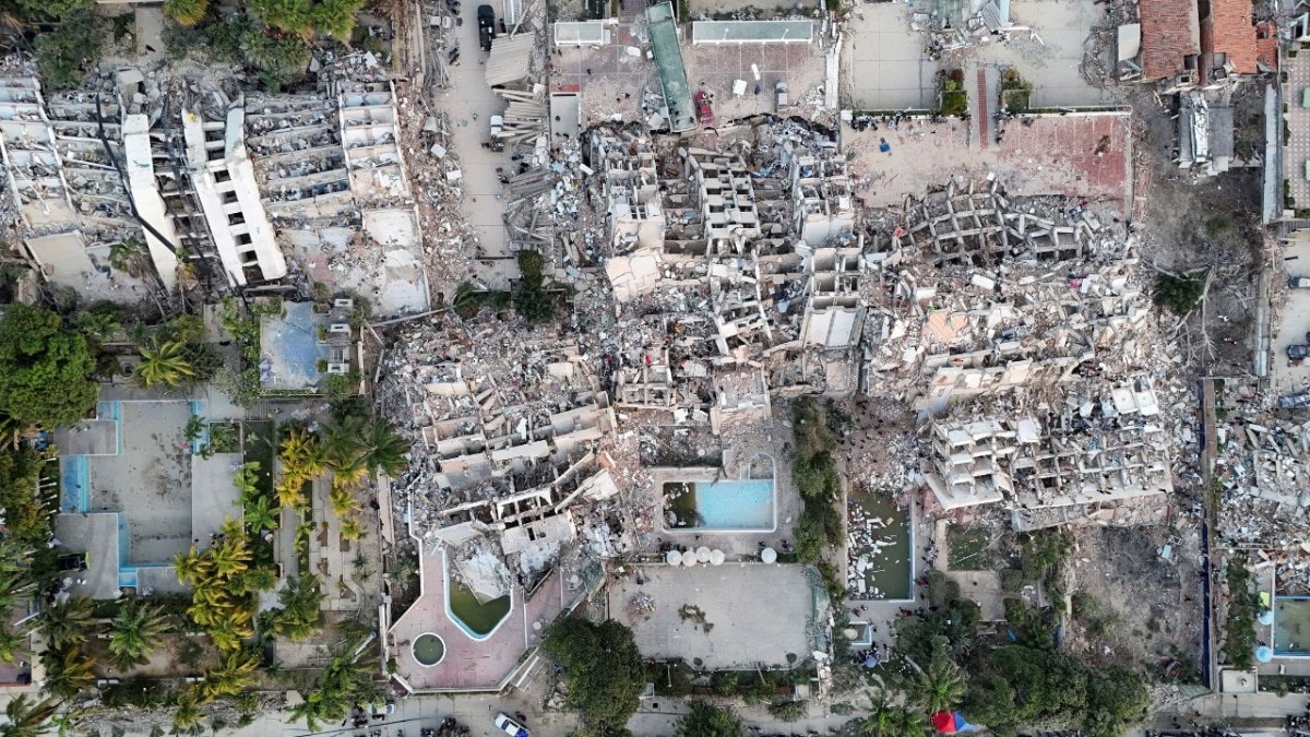
- NASA uses satellite imagery and data to support earthquake impact assessment in Venezuela.
- Estimates indicate roughly 58,000 buildings are damaged, with figures reported around 58,870.
- Reported estimates cover buildings likely damaged or destroyed by the earthquakes.
- NASA imagery is described as helping teams on the ground assess impacts and guide response efforts.
- The figures come from a rapid satellite assessment rather than direct field verification in the reports.
A rapid satellite imagery assessment released by NASA this week indicated that roughly 58,870 buildings in Venezuela were likely damaged or destroyed by last week's devastating earthquakes. The post NASA: Venezuela Earthquakes Damaged or Destroyed Nearly 60,000 Buildings appeared first on Breitbart.
8 hours agoNASA satellite scan finds buildings damaged in Venezuela twin quakes
19 hours agoNASA said that its satellites were "providing critical support, capturing imagery and data to help teams on the ground assess impacts and guide response efforts."
21 hours ago
World’s oceans record hottest June as El Niño and climate change raise risks
Scientists say the world’s oceans experience their hottest June on record, with European monitoring showing record-high...

Venezuela twin earthquakes: death toll rises as rescue teams search for survivors
Rescue and recovery operations continue in Venezuela after two powerful earthquakes struck near Caracas in the week’s se...

FBI says all Nancy Guthrie ransom notes sent to media are fake
The FBI says all three ransom notes connected to the disappearance of Nancy Guthrie are fake. According to reports, the...