Multiple outlets report that a data-driven map compiled by The Sydney Morning Herald newspaper details patterns of violence linked to Sydney’s ongoing gang war over the past two years. The coverage describes the map as aggregating information on incidents including shootings, firebombings and other underworld-related attacks. The reporting states that the visualisation shows where incidents cluster across the city, illustrating how violence is distributed in different areas rather than occurring randomly. While the articles characterise the period as a two-year stretch of “bloody” conflict, they generally focus on the mapped trend of incidents rather than providing new information about specific prosecutions or particular perpetrators. Together, the sources emphasise that the map relies on compiled data to reveal the scale and geographic distribution of violence, and they highlight the impact on Sydney as reflected in the number and variety of incidents recorded during the period. The articles present the map as an attempt to make incident data easier to understand for readers looking at the broader pattern of gang-related violence.
Herald map charts pattern of shootings and attacks in Sydney’s gang war
Multiple outlets report that a data-driven map compiled by The Sydney Morning Herald newspaper details patterns of violence linked to Sydney’s ongoing gang war over the past two years. The coverage de...
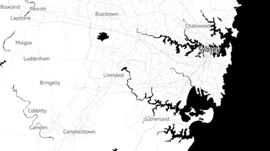
- A map compiled by The Sydney Morning Herald presents incident data on Sydney gang-related violence over about two years.
- The incidents described include shootings and firebombings.
- The coverage says the map shows how attacks are distributed across different parts of Sydney.
- The articles are based on compiled data and focus on identifying patterns rather than detailing a single case.
- Multiple outlets, including the Brisbane Times and The Age, run the same story using the Herald’s compiled data.
Data compiled by the Herald reveals the shocking pattern of shootings, firebombings and underworld violence that has scarred the city.
5 hours agoData compiled by the Herald reveals the shocking pattern of shootings, firebombings and underworld violence that has scarred the city.
5 hours agoData compiled by the Herald reveals the shocking pattern of shootings, firebombings and underworld violence that has scarred the city.
5 hours ago
Rahul Dravid’s son Anvay named in India U-19 squad for Sri Lanka tour
India’s Under-19 squad includes Anvay Dravid, the younger son of former India captain and legendary batter Rahul Dravid....

MHT CET 2026 Results Declared for Management, Hospitality, Nursing and Computer Applications
The State Common Entrance Test Cell, Maharashtra (State CET Cell) has declared the MHT CET 2026 results for multiple cou...

Hrithik Roshan to replace Shah Rukh Khan in Jailer 2, set to reunite with Rajinikanth
Hrithik Roshan is reported to be joining “Jailer 2” alongside Rajinikanth, marking their reunion after appearing togethe...