


NASA and Phys.org both report on a study using radar observations to map how crops change during the Southern Hemisphere’s growing season in South Africa’s Maize Triangle. Researchers use radar data collected over an agricultural area to distinguish crop types and observe shifts over time. The results are presented using a vivid, color-based visualization that highlights variations in the landscape as the growing season progresses. The study’s central focus is on demonstrating that radar can capture information about vegetation and crop patterns, allowing researchers to track how different crops appear and change through the season. By showing temporal changes rather than a single snapshot, the mapping approach helps reveal the dynamics of planting and growth across the region. The coverage emphasizes the use of radar data and the resulting visual outputs to represent crop types and their evolution during the season, rather than concentrating on any single crop yield or policy outcome.
Radar maps track crop types across South Africa’s Maize Triangle growing season
NASA and Phys.org both report on a study using radar observations to map how crops change during the Southern Hemisphere’s growing season in South Africa’s Maize Triangle. Researchers use radar data c...
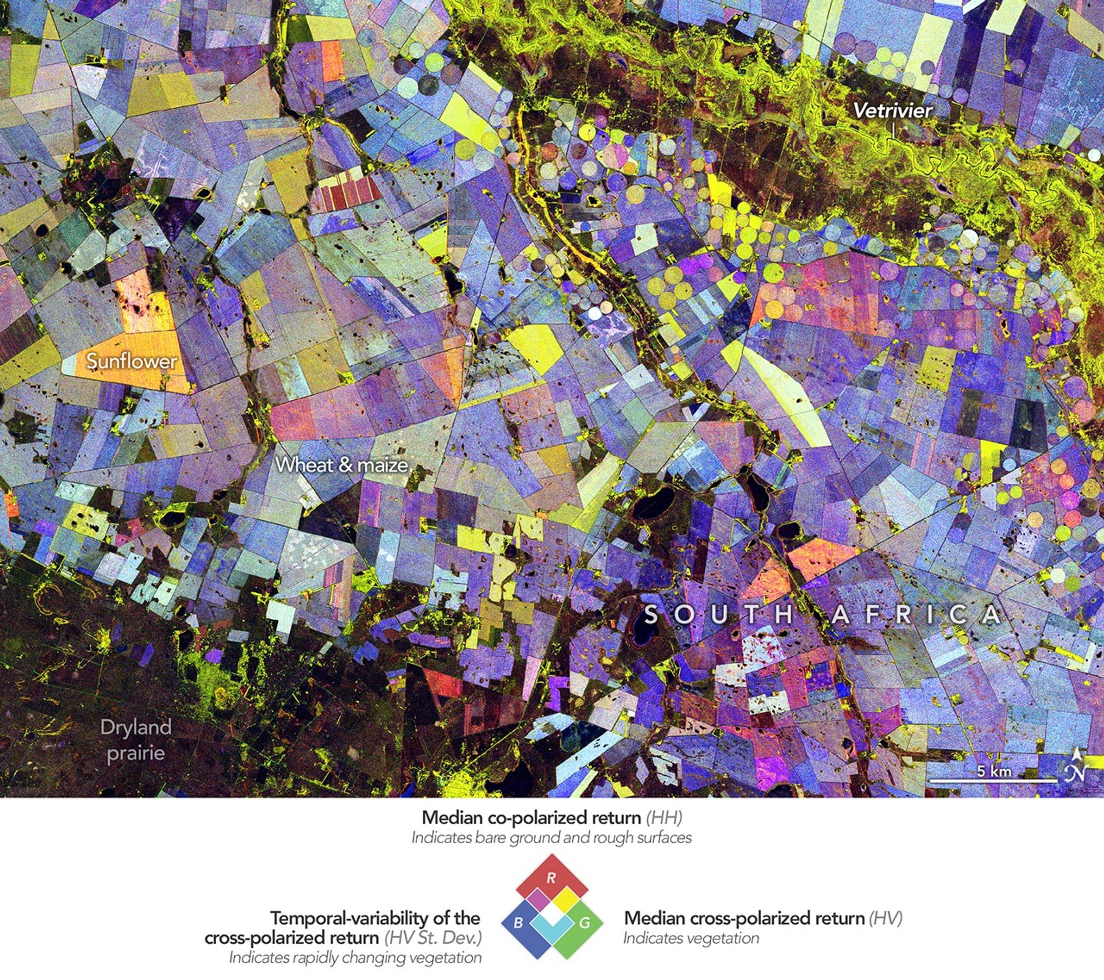
- Both outlets describe the use of radar data to map an agricultural area in South Africa.
- The work focuses on South Africa’s Maize Triangle.
- The mapping identifies crop types and tracks how they change across the Southern Hemisphere growing season.
- The results are presented as color-based visualizations derived from the radar observations.
- Both sources emphasize seasonal, time-varying crop patterns rather than a single-time map.
Radar data from an agricultural area in South Africa, shown in a vivid color palette, reveal crop types and how they changed during the Southern Hemisphere's growing season.
2 months agoRadar data from an agricultural area in South Africa, shown in a vivid color palette, reveal crop types and how they changed during the Southern Hemisphere’s growing season.
3 months ago
West Point Climate Professor Fired After Refusing Order to Stop Teaching Human Causes, Lawsuit Says
A professor at the U.S. Military Academy at West Point is suing the academy, alleging he was fired after refusing to sto...
Super El Niño forms, with forecasts indicating a record-strength event
El Niño has formed and is rapidly strengthening, with multiple agencies and researchers saying it is likely to become on...

Trump signs order creating U.S. Space Academy for military and civilian space workforce
President Donald Trump signs an executive order creating the U.S. Space Academy, setting up a new institution focused on...